Heritage hikes
Eugenia Falls Conservation Area
*Note, this original article appeared in the Fall 2022 issue of Marathon of History Magazine and the spring 2023 edition of Grey Bruce Kids.
Though not for the faint of heart, hiking the Bruce Trail at the Eugenia Falls Conservation Area has many redeeming qualities, making the challenging conditions worthwhile. Located at the cusp of the Beaver Valley, on the west side of the hamlet of Eugenia, the falls have been well known to the local population since they were set aside as part of a conservation area in 1957. Even before this designation as a protected property, Eugenia Falls was noted in the diaries and newspaper accounts of travelers who marveled at the beauty and power of the 30-metre waterfall. Though visiting the falls has been a staple for those living in the Grey-Bruce area for quite some time, its rocky paths and ancient cedar trees have recently seen an explosion in visitors, particularly during the pandemic.
When the popularity of a natural location rises, however, the risk of the added foot traffic damaging the sensitive ecosystem also increases. This dynamic often compels the authorities that care for these areas to implement protective measures; this is precisely what has occurred at Eugenia Falls. Though most visitors to the area have heeded the pleas to stay on marked trails and steer clear from the sheer cliff edges in the park, the Grey Sauble Conservation Authority, in cooperation with the Bruce Trail Conservancy, has taken the unfortunate, but necessary, step of fencing off the north side of the gorge. This move, however, does not reduce the overall enjoyment of the park, as the splendid vistas of the falls and Cuckoo Valley remain untouched.
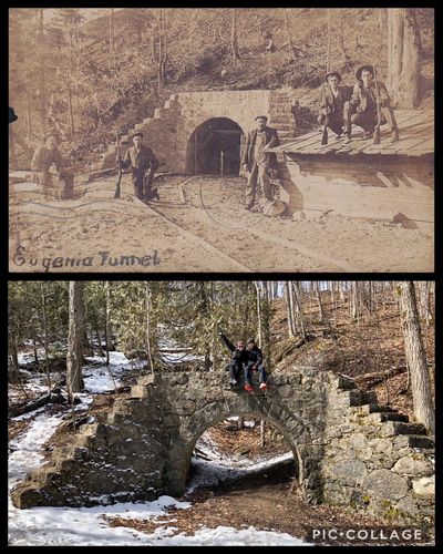
Apart from being a peaceful and beautiful landscape, the Eugenia Falls Conservation Area has its share of hidden and fascinating history. Mysterious stone arches found on the property are a constant source of intrigue to visitors. Hiding in these beautifully crafted arches is not just the tale of failed experiments in power generation, but a reflection of early 20th century attitude where conquering nature, by any means, was seen as a necessary step in the forward march of progress.
Like almost any account of North American history, it must start with the end of the last ice age. Approximately 12,000-13,000 years ago, the last of the Wisconsin ice sheet receded from what is now south-western Ontario, leaving in its wake a series of deep gouges and irregular scrapings. This glacial bulldozing not only resulted in the creation of the Great Lakes basins, but revealed a stunning layer of rock, too hard for the glaciers to flatten, that is now known as the Niagara Escarpment. The beautiful Beaver Valley, into which the conservation area’s namesake Eugenia Falls cascades, is a charming remnant of this turbulent geological time.
The village of Eugenia itself, like many small Ontario hamlets in the mid-1800s, developed organically over a relatively long period. Early settlers in the Grey-Bruce area were attracted to sources of power, such as Eugenia’s Beaver River, which provided propulsion for early saw and grist mills. The village is named after Princess Eugénie de Montijo (1826-1920), the wife of French Emperor Napoleon III (1808-1873). Members of the original survey team in the Eugenia area were former French military engineers and their militaristic influence on the village is evident in the street names such as Napoleon, Redan and Zouave.
In 1853, the hamlet was rife with excitement as it was rumoured that gold had been discovered in the valley below the falls. What is now acrimoniously referred to as the “Eugenia Gold Rush” turned out to be nothing more than the chance discovery of pyrite, commonly known as “fools’ gold.”
Aside from an ephemeral bout of gold speculation, Eugenia’s settlement pattern resembled other growing communities in Grey and Bruce Counties through the latter half of the 19th century. A collection of dwellings, sawmills and churches serviced the population. Excitement would return once again in the late 1890s as speculation in electrical power generation enthralled the village. Looking to capitalize on profits that the new technology promised, businessman William Hogg built a small power generation station on the south side of the river, just to the east of the falls, located in what is now the main conservation area. Water from the river was used as propulsion for an electricity generating turbine operating in a stone powerhouse. The scheme faded out as the river provided only limited generating power and didn’t prove to be profitable enough to invest further capital in. Though heavily vandalized and decorated with graffiti, the stone portion of the structure that housed the generation equipment remains for visitors to explore.
Another hydro-electric plan was hatched in the early 1900s by a consortium calling itself the Georgian Bay Power Company. It would see a 52-inch pipe run nearly 800 feet north from the Beaver River, just above the falls, descending through the side of the escarpment into a generating station located on the valley floor. It was initially projected that the generation station would produce 2400 horsepower in the span of a 10-hour day. This plan involved the costly procedure of excavating an 800-foot tunnel, which would house the water pipe, through the escarpment or “Eugenia Mountain,” as several overly dramatic newspapers referred to it. Work began on the tunnel in 1906 and was completed in 1907, however, the costs of the project nearly bankrupted the Georgian Bay Power Company and work was halted. The Ontario Government took control of the enterprise several years later, buying out the assets of the Georgian Bay Power Company. Provincially funded work to generate electricity and involving the construction of a massive dam on the Beaver River, to the east of Eugenia, began in 1914. When completed, the flooded area covered roughly 1,170 acres and was now known as Eugenia Lake. To produce power, water descends through pipes from the lake to a generating station located on the valley floor, a journey of roughly one kilometre. Officially opened in November 1915, this power generation facility is still in operation over 117 years later using the water of the Beaver River and Eugenia Lake. The generating station’s use of water power for so long lends credence to the original plan of diverting water through pipes to the valley floor. However, the volume of water available from Lake Eugenia today vastly eclipses that which would have been available from smaller dams located near the top of the falls.
While enjoying the trails in the Eugenia Falls Conservation Area, it is recommended to visit the remaining stone tunnel entrances, reminders of the ambitious designs of the Georgian Bay Power Company. The tunnel was filled in for safety reasons but the stone archways serve as a memento of what was once expected to be a profitable undertaking. One archway is located on the north side of the Beaver River in the park, near the brink of the falls. The corresponding arch, or what was once the other end of the tunnel, is located about one kilometre north of that spot and is hidden in the woods, just off of the Bruce Trail.
The main trails and side trails in the Eugenia Falls Conservation Area are mostly single track, well marked and hard packed. Nevertheless, great care must be taken, particularly near the river above the falls, as very irregular rocks on the trail guarantee unhappy results from any missteps. Sturdy shoes are a must, and due to the rugged terrain, exploring with a friend is recommended. Carrying a water supply with you is also a good plan, particularly during the summer months. Parking is limited on weekends in the Conservation Area parking lot. Several smaller Bruce Trail lots are located nearby within a short hike of the park. Additionally, the Bruce Trail website and mobile app are excellent sources for updated parking information, trail alerts, and other tips to help make a day at the Eugenia Falls Conservation Area enjoyable for all.
Heritage hikes
Canadian National Railway wye - Durham, On.
Unique historical experiences can be found inconspicuously hiding in places less traveled, many almost untouched by todays world. Tucked into the corner of the small town of Durham, located in southern Grey County, is a unique walking experience that harkens back to the early days of railroads in the region. Here a leisurely stroll can be made following old railway lines that once serviced booming industry in the now sleepy small town. Though many communities have converted former railway lines into walking trails, the Durham trail has a certain rugged beauty. In places it’s as if the tracks had only just disappeared, though that happened nearly 40 years ago. The highlight of the municipal trail system for historians and railway enthusiasts alike is an old Canadian National wye hidden in a marshland in the south-west corner of the small town. This easy to miss attraction will have you asking wye didn’t I know this was here. (Sorry)
The wye was a common railway feature particularly during the age of steam. Allowing trains to turn in any direction depending on where and how freight was to be loaded it was a simple but effective track configuration. In the example of the overgrown wye located in Durham, trains entered the town from the south and then had the opportunity to complete the two-point turn maneuver to reverse into either Krohler Furniture or the Durham Stone crushing facility, both located roughly two kilometres from the wye. Because Durham was the end-of-the-line, literally, the wye was imperative to allow trains around for the return trip south. To the keen eye several features on this trail stand out. Lumber that once provided structural support to the tracks and switches still protrudes from the ground in several places. The track bed itself is a marvel of early engineering being heavily built up keeping the rails up out of the swampy ground. The wetland in which the wye is situated provides nature lovers with ample opportunity for wildlife sightings, bird watching and in the winter the occasional snowy owl has been known to make brief appearances. The wye built in a swamp reminds us of an era when environmental concerns did not deter progress. Fortunately this marsh has evaded further development and now provides a glimpse of a beautiful untouched natural landscape.
The trail is part of an ongoing project to eventually have many kilometres of marked footpaths surrounding the town that certainly lives up to its motto; ’nestled in nature.’ The West Grey trail committee which is headed up by councillor Doug Hutchinson lists preserving the historic roots of the town as one of the groups primary concerns.
There is limited parking immediately at the wye, fortunately ample parking can be found a short walk away. Free parking is available at a municipal lot, located at the corner of Queen and Saddler streets, one block west of highway 6 and one block south of Grey Road 4. From here the community trail heads south following the beautiful Saugeen river for roughly 300 meters before merging into the old railway bed. From the merger point the trail crosses park street and continues south for another 300 meters before crossing Douglas Street where the wye can be found on the south side. Standing on Douglas Street looking south both the east and western portions of the wye are easily discernible, however only the left, or eastern branch allows public access.
It is an accessible trail suitable for any skill level and a must see for railway history buffs. Durham is a busy tourist town in the summer months however the wye is located away from the majority of tourist attractions such as the magnificent waterfalls so for a quiet stroll it is ideal.
